South Zapata Lake Colorado Hike Guide
South Zapata Lake is a high alpine lake located in the Sangre de Cristo Range of southern Colorado. While Zapata Falls below is a popular hiking destination, the lake is a relatively quiet trip off the beaten path. Trail conditions up to the lake range from packed dirt to some open grassy plains at the top with several creek crossings along the way.
South Zapata Lake Quick Facts
South Zapata Lake Rating: ★★★★ ( 4/5 Stars)
Distance: 9.8 Miles RT
Elevation Start: 9,089 ft
South Zapata Lake Elevation: 11,800 ft
Total Elevation Gain: 3,000 ft (approximately)
Estimated Time to Complete: 6-8 hours RT
Difficulty: Moderate What does this mean?
Class: Class 1 – What does this mean?
Season: June – September (expect snow outside of this period)
Directions to South Zapata Lake
Trailhead: South Zapata Creek
Getting Here: There are a variety of ways to get to South Zapata Lake, but they all start at the Zapata Falls trailhead right outside of Alamosa, Colorado. Your best bet would be to plug your starting location into Google Maps or your favorite navigational device with an end destination of Zapata Falls. One thing to note, once you turn on to the Zapata Falls road (dirt), you are about 4 miles from the TH. These 4 miles are a bit rough and some lower clearance cars may have a tough time in sections. However, in general this road is doable for most vehicles.
Parking: Parking for South Zapata Lake is shared with Zapata Falls, Ellingwood Point & Blanca Peak, so expect other cars year round. However, the lot is free and can fit about 20-30 cars. In the summer, this lot will absolutely fill up on weekends, so try to get to the parking area earlier or later in the day. There is a non-plumbing bathroom at the trailhead in addition to a doggy poop bag dispenser.
Summary
Dogs: South Zapata Lake is a dog friendly trail with plenty of water sources along the way. Be aware there are several creek crossings with few shallow or dry paths across (i.e., if you just gave your dog a bath, go ahead and schedule another one). The start of the trail does have trash cans for your poop and may have poop bags as well if you forget yours.
Camping: The most popular option to camp near South Zapata Lake would be to camp at the official Zapata Falls campground (located about 500 yards from the trailhead – $9 fee, does not accept reservations). This campground will fill up, even in winter months (there are are only about 20 official spots to camp). If that area is full, you could also camp at Great Sand Dunes National Park Pinon Flats campground which is open from April-October each year. During the winter, the campground inside the park is closed so you will have to seek alternative options. If you want to hike in a bit, your best bet would be to camp around the 3 mile mark when the land flattens out a bit. If you want to camp near the lake, you can do that…but honestly, the options are not stellar.
Make it a Loop: South Zapata Lake is an out and back hike. However, you can easily add other hikes in the area: Blanca & Ellingwood Point , Zapata Falls or Great Sand Dunes National Park.
Trail X Factors: Elevation Gain
When you first start your hike to South Zapata Lake, you may see an old trailhead sign along the way. If you look closely, you can see someone has carved into the sign something like “Hike is longer than described and is straight up from here on out. Very difficult!” I read that and said “oh shit.” While it may have been a bit of an exaggeration, the hike up to South Zapata Lake was still very taxing on my legs. From the trailhead up to the lake, you are almost constantly gaining elevation.
Hike Tip(s): As previously mentioned, this trail includes several creek crossings with no clearly establish paths. Be prepared to hop across slippery rocks and potentially have your feet partially submerged at times. Water-resistant boots are highly recommended for this trip, especially in the early summer months when snow runoff is high.
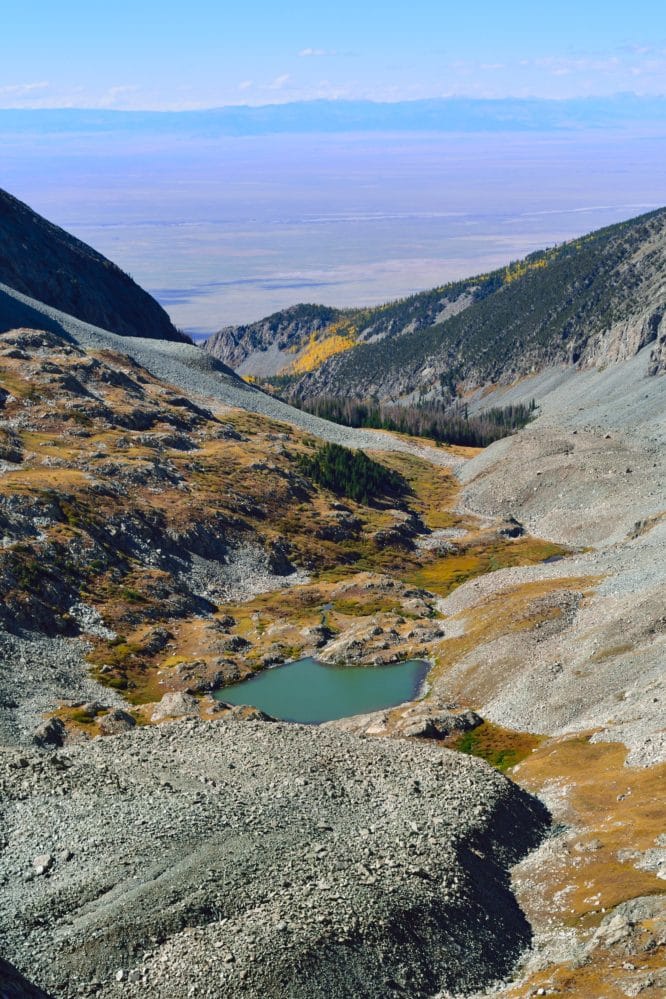
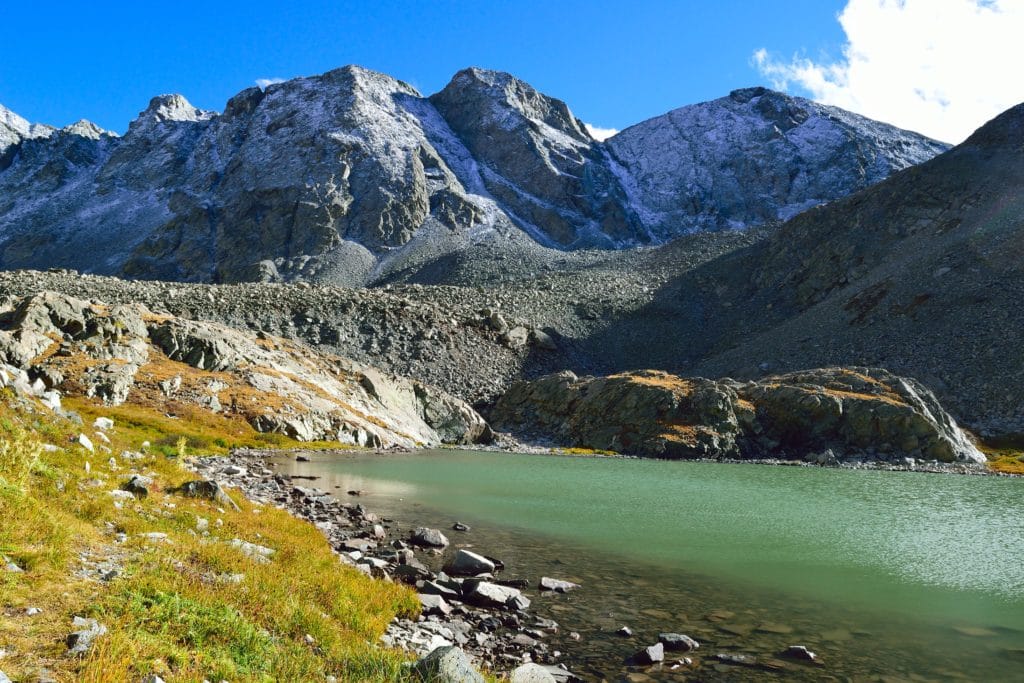
Best Views: In my opinion, the best views on this hike come at the lake itself and working up the valley. I would strongly recommend this hike in the fall when the leaves are starting to turn and the mountains are dusted with snow. However, year round there are awesome views of Great Sand Dunes National Park and the Sangre de Cristo Range. This area is known to have mountain goats, big horn sheep and other native animals.
South Zapata Lake Hike Route
Includes hike up to Ellingwood Point & Blanca Peak