Colorado 14ers Ranked by Difficulty: All 58 Peaks From Easiest to Hardest
After hiking all 58 Colorado 14ers and logging more than 140 total 14er summits, I created this ranking to help hikers determine which peaks to tackle next. These Colorado 14ers are ranked from easiest to hardest based on mileage, elevation gain, route finding, trailhead accessibility, exposure, and technical difficulty. Whether you’re searching for the easiest Colorado 14er to start with or wondering which peaks are considered the hardest in the state, this guide ranks all 58 peaks using firsthand experience from over a decade in the mountains of Colorado.

Why Trust This Ranking?
Before diving into my ranking of the Colorado 14ers, it’s important to understand how these rankings were created. I have completed all 58 of Colorado’s 14ers and stood on more than 140 total 14er summits. Over the last decade, I’ve experienced these mountains across a wide range of conditions, seasons and trailhead access situations. I’ve summited them as a hiker, trail runner and snowboard mountaineer, including more than 15 of them with my dogs and snowboarding down 10+ Colorado 14ers. In addition, I have completed all four of Colorado’s Great Traverses, giving me experience on many of the state’s most committing and technical alpine routes.
While any ranking of the Colorado 14ers is inherently subjective, the list below reflects my firsthand experience on each mountain’s standard route. Rankings are based on factors including mileage, elevation gain, trailhead accessibility, route finding, exposure, scrambling difficulty and overall commitment level.
Ranking Criteria for The Colorado 14ers
- Ranking Colorado 14ers by difficulty is inherently subjective. Factors such as fitness level, weather, trail conditions, snowpack, route-finding ability and previous hiking experience can dramatically impact how difficult a mountain feels. To make these rankings as objective as possible, I considered several factors including mileage, elevation gain, trailhead accessibility, route finding, exposure, scrambling difficulty and overall commitment level.
- All peaks in the rankings are assuming dry (Summer) conditions and good weather from the “standard” route. The standard route refers to the trail or way up the 14ers that is most commonly hiked.
- There is no “easy 14er” despite what you may read online. For the average hiker, every 14er, even the easiest on this list are going to present challenges that most hikes in the United States do not.
- The mountains are grouped by difficulty level, but not ranked within these categories.
- All are ranked assuming you can get to either an upper or lower standard TH and hiking the standard route, unless otherwise noted.
- Looking to understand the Class system? Check out this post. Note that exposure and the Class of a hiking are not always intertwined, aka=more exposure on a mountain does not always mean higher class.
Ranking the Colorado 14ers
Tier 1: The Easiest Colorado 14ers
While no Colorado 14er is truly easy, these peaks offer the most approachable standard routes in the state for those hikers looking to stand on their first 14er summit.. Most feature well-defined trails, limited route finding, lower exposure and relatively moderate mileage and elevation gain compared to the more difficult Colorado 14ers ranked later in this guide. If you’re looking for your first Colorado 14er or wondering which mountains are best for beginners, these are the peaks I would recommend starting with.
- Handies Peak – One of the shortest and most beginner-friendly Colorado 14ers if you can access the upper trailhead.
- Mt Sherman – Short hike, but steady elevation (assuming you can get to upper TH), slightly longer if not. Lots of false summits here.
- Mt Lincoln – Longest single approach of any DeCaLiBron14er with some minor higher class 2 moves towards the summit. However, in order to get here, you must first summit Mt Bross or Mt Democrat and then Mt Cameron.
- Mt Cameron – Zero route finding, steady elevation gain from car to summit. Class 2 hiking.
- Mt Bross – Some route finding, especially in spring/early summer – steady elevation gain from car to summit. Class 2 hiking.
- Mt Bierstadt – Extremely popular with zero route finding and steady elevation gain from car to summit. Class 2 hiking for about a quarter mile near summit.
- Uncompahgre Peak – Approach typically requires a 4×4 car otherwise add some mileage. I’ve hiked from both Wetterhorn Creek but the standard approach is similar. Steady but slow elevation gain and low class 2 hiking. Minimal route finding with either approach but the summit block does have some exposure.
- Mt Democrat – Extremely straight forward, popular and steep hike. Class 2 hiking.
- Mt Blue Sky – Via Summit Lake, Mount Blue Sky offers one of the shortest and easiest Colorado 14er routes. However, alternate approaches such as the Sawtooth Ridge from Mount Bierstadt or the route from Echo Lake significantly increase the difficulty due to additional mileage, route finding, and exposure
Tier 2: Moderate Colorado 14ers
These Colorado 14ers represent the next progression for hikers looking to build experience beyond the state’s easiest peaks. While the routes in this tier generally avoid sustained technical scrambling and extreme exposure, they often feature longer mileage, greater elevation gain, more route finding or increased overall commitment. Many hikers will find these mountains more physically demanding than the peaks in Tier 1, making them excellent choices for developing the skills, fitness, and experience needed before tackling Colorado’s most advanced 14ers.
- San Luis Peak – Probably the most remote Colorado 14er. While the hike itself is straightforward Class 1 terrain, changing road conditions can significantly increase the overall commitment and mileage required.
- Huron Peak – Steady elevation gain and slightly longer approach if no 4WD. Very popular hike with steep ridge before summit. Class 2 hiking but one of the most beautiful peaks in the state.
- Grays Peak – One of the most popular Colorado 14ers with straightforward Class 1 hiking and minimal route finding. Difficulty largely depends on access to the trailhead.
- Torreys Peak – Similar to Grays Peak when climbed via the standard route, but slightly more difficult due to additional distance and Class 2 terrain. Alternative routes such as Kelso Ridge add significant exposure, scrambling and route-finding challenges, making for a great intro scramble.
- Culebra Peak – One of Colorado’s only privately owned 14ers. The hike itself does not have a trail but is still fairly straightforward. Permit requirements and access restrictions make it unlike any other peak on this list.
- Mt Princeton – Borderline easy depending on how high you can drive. Class 2 hiking with some route finding, especially to gain main ridge.
- Humboldt Peak – Moderate assuming you start from upper TH, more difficult if starting from lower TH. Steady elevation and some route finding required in spring months. Class 2 hiking with 1/2 higher class 2 moves towards summit.
- Mt Sneffels – A borderline easy hike but putting at moderate because of class ¾ move near summit and that most vehicles will not make it to the upper TH.
- Red Cloud Peak – Steady elevation gain from TH and longer mileage but minimal route finding and all low class hiking. Class 2 hiking with some exposure.
- Sunshine Peak – Almost identical hike to Red Cloud but with some added elevation gain/loss. Class 2 hiking.
- Mt Belford – Very steep from TH all the way to the summit. Class 2 hiking on steep trail almost the entire time.
- Mt Shavano – Long mileage and steady elevation gain from TH. Class 2 near summit.
- Missouri Mountain – Steep approach, some route finding required, sketchy/ loose travel on ridge and Class 2.
- La Plata Peak – This peak can be tricky in the spring as route finding becomes a major issue (like many peaks). However, once you get above treeline its a steady straight up hike to the summit. Steep class 2 hiking.
- Mt Yale– Steady elevation gain from TH with steep slope and some class ⅔ hiking near summit.
- Mt Columbia – Trail improvements recently done, but medium approach and loads of route finding if hiking from Mt Harvard. Minimal route finding and steady elevation from TH. Class 2 hiking.
- Quandary Peak – Sustained elevation from TH, lots of false summits and super popular hike which can lead to crowds on trail. Class 1 hiking.
Tier 3: More Difficult Colorado 14ers
These Colorado 14ers mark the transition from physically demanding hikes to mountains where route finding, exposure, scrambling and overall commitment become increasingly important. While many of these peaks can still be completed by experienced hikers without technical climbing equipment, mistakes begin to carry greater consequences and strong mountain judgment becomes essential. Hikers entering this tier should be comfortable with exposure, hands-on scrambling, and navigating more complex terrain than the peaks found in the previous categories.
- Mt Elbert – Sustained elevation gain from TH, loose rock in sections and longer hike. No route finding required with drier conditions. Class 1 hiking to Colorado’s highest peak.
- Mt Antero – Super long mileage and steady elevation gain if no 4×4 car. If you have a high clearance 4×4 this moves to an easier hike. Class 2 hiking, only near summit though.
- Kit Carson Peak – Long approach with lots of elevation gain/loss and some class 3 hiking. Requires a hike up Challenger Point before summiting which adds to difficulty. Ledges can be super dangerous with snow and lots of loose rock in Class 3 section.
- Challenger Point – Long approach with steady elevation gain and poor trail conditions which requires some route finding. Class 2 hiking and trail conditions may improve in future years as trail work is being done. One of my least favorite mountains in the state.
- Wetterhorn Peak – Depending on starting point could be hard hike. If able to start at TH, steady elevation gain, some exposure and class 3 hiking. One of my favorites!
- Wilson Peak – Medium approach, camping typically required and elevation gain is steady from TH to summit. A handful of fairly exposed moves. Class 3.
- Mt Lindsey – Interesting hike as there are two variations to take to summit. Both are class 3 and involve some poor trail conditions. Long approach and heavy exposure if taking ridge direct. Accessibility issues in years past due to private land.
- Mt Massive – From either fish hatchery or standard route, lots of elevation gain and some route finding. Class 2 hiking up Colorado’s second highest peak. Accessibility issues in past due to Willow Creek Fire.
- Mt Harvard – Longer mileage and steady elevation gain with some high class 2, low class 3 moves towards the summit.
- Castle Peak – If able to drive to upper TH this is moderate, but if not, super long approach with lots of elevation gain. Class 2 though and not a ton of exposure. Descent can be very sketchy in spring/early summer, ax and crampons typically required.
- Conundrum Peak – Have to summit neighboring Castle Peak first, lots of elevation gain, long approach and a tough descent down the saddle (with snow or back up to Castle without.) Class 2 hiking.
- Mt of the Holy Cross – Longer mileage, steady elevation gain, some route finding and class 2 hiking. Feels very remote and the regain of elevation on the way back to the car makes this one unique.
- Mt Oxford – Similar to Mt Belford, but with a lot more elevation gain/loss and added mileage due to going back up Mt Belford on the way down. Class 2 hiking, mostly on way down to saddle, some exposure.
- Tabeguache Peak – Similar to Shavano, but more mileage and elevation gain/loss back up to Mt Shavano on loose rock conditions. Class 2 hiking.
Tier 4: Hard Colorado 14ers
These hard Colorado 14ers require a significant step up in experience, fitness, hiking/scrambling technique and mountain judgment compared to the previous tiers. Exposure becomes more frequent, route finding can be challenging, technique becomes vital and scrambling is often sustained for longer periods. While these peaks are achievable for experienced hikers, they demand careful preparation, a clear weather forecast and comfort operating in complex alpine terrain.
- Pikes Peak (via Barr trail) – Longest standard 14er approach, camping typically required, but doable in (very) long day – almost no technical hiking otherwise would one of the hardest 14ers in Colorado. Nearly a marathon with nearly 7,000ft of vertical gain and loss and extremely exposed to the elements.
- Pyramid Peak – Lots of elevation gain, all at once, on loose trail. Lots of Class 4 hiking but medium exposure. Lots of downclimbing which is one of the most difficult parts of scrambling in my opinion.
- Sunlight Peak – If not taking the train, hardest tier. Regardless, lots of elevation gain class 3 hiking and the 2nd most exposed move on a standard 14er in my opinion with the “leap of faith”. Note: The leap of faith scared me way more than the knife edge on Capitol did. Class 4.
- El Diente Peak – Camping typically required, medium approach and lots of elevation gain all at once. Some route finding and loose conditions to deal with. Class 3 with lots of exposure. See below for my notes on completing this as part of the El Diente to Wilson traverse.
- Mt Wilson- Long approach, Class 3 and some route finding. If completed via the El Diente Traverse, this route becomes one of the hardest and most committing Colorado 14er experiences.
- Mt Eolus – If no train, hardest – sustained exposure on shelves, looser conditions and lots of class 3 and 4 with some route finding involved. Most technical and hardest of Chicago Basin hikes in my opinion.
- North Eolus – If no train, hardest – long and steep approach to Twin Lakes with lots of elevation gain. Steady elevation and minimal route finding to summit. Class 3.
- Windom Peak – Generally considered the easiest of the Chicago Basin 14ers, with mostly Class 2 terrain and limited Class 3 scrambling. Some route finding, but this could easily be a tier below if you are taking the train in.
- Blanca Peak – Long and arduous approach from Lake Como often makes camping necessary. Sustained elevation gain, tedious talus and sections of route finding make Blanca significantly more difficult than its Class 2 rating suggests.
- Ellingwood Point – Shares the same demanding approaches as Blanca Peak with significant elevation gain and a long day regardless of route choice. Sustained Class 2 terrain with several tedious sections of talus.
- Longs Peak – Long approach, steady elevation gain and good mix of loose conditions and sustained class 3 climbing. Higher exposure on ledges/narrows and downclimbing required on descent. Lots of loose and slick rock as well which can make trusting your footing, difficult.
Tier 5: Hardest Colorado 14ers
These are the hardest Colorado 14ers via their standard routes and represent the most serious individual mountain challenges in the state. Significant exposure, sustained scrambling, complex route finding, objective hazards and severe consequences for mistakes are common throughout this tier. While physical fitness remains important, success on these peaks often depends more on experience, confidence, decision-making, comfort operating in high-consequence alpine terrain and frankly, luck. Many hikers spend years developing the skills required to safely attempt these mountains. While the peaks below represent the highest tier of individual summits, Colorado’s Four Great Traverses introduce an entirely different level of complexity and commitment.
- Capitol Peak – Capitol Peak has everything: a long approach, sustained exposure, tons of route finding, loose terrain that could easily result in a serious fall, limited production from the elements and of course the infamous Knife Edge. In my opinion, Capitol Peak is the hardest standard route Colorado 14er.
- Little Bear Peak – Class 4 climbing through the Hourglass, significant rockfall danger and a long approach that often requires camping. In my opinion, descending the Hourglass is more difficult and dangerous than climbing it. Little Bear Peak is a very dangerous mountain.
- Maroon Peak – Long approach, lots of elevation gain, loose terrain and exposed Class 3 and 4 moves along the way. The required permit makes this one even more trickier to hike.
- North Maroon Peak – Very similar to Maroon Peak but the exposed Class 4 move and downclimb near the summit makes this peak harder than Maroon in my opinion.
- Crestone Peak – Long approach, substantial elevation gain and sustained Class 3 scrambling. Don’t forget you need to reclimb and descend Broken Hand Pass. While the standard route is relatively straightforward compared to others in this tier, the length of the day and steep terrain create a significant challenge.
- Crestone Needle – Long approach, significant elevation gain, steep Class 3 and 4 scrambling, sustained exposure and route finding through complex terrain. Some of the best rock quality and one of the most aesthetic and engaging standard routes on any Colorado 14er.
- Snowmass Mountain – The second-longest standard Colorado 14er approach with substantial elevation gain, mandatory route commitment and sections of Class 3 scrambling. Snow often lingers well into summer, creating additional hazards and route-finding challenges. Personally, this one is easier with snow but that also requires more gear and mountain skills/knowledge.
Colorado’s Four Great Traverses Ranked by Difficulty
Popularized by legendary Colorado mountaineer and author Gerry Roach, the Four Great Colorado 14er Traverses represent the pinnacle of non-technical mountaineering in Colorado. These routes combine multiple fourteeners, complex route finding, sustained scrambling, significant exposure and serious commitment into a single objective. In my opinion, every Great Traverse is more difficult than any standard Colorado 14er route and its really not particularly close. They require a higher level of fitness, technical ability, a mountaineer level skillset, mental toughness and loads of experience in the high alpine to safely complete. The rankings below are based on my personal experience completing all four of Colorado’s Great Traverses. While there are many other Colorado 14er traverses and ridge connections, the four routes below are the most recognized and are widely considered the state’s premier alpine traverses.
- Little Bear Peak to Blanca Peak Traverse– Extreme exposure, significant route finding, Class 4 and low Class 5 moves and a tremendous amount of exposed downclimbing. In my opinion, the sustained exposure throughout this traverse makes it the hardest of Colorado’s Four Great Traverses. Oh and don’t forget you need to hike up Little Bear Peak and down Blanca Peak too.
- Maroon Bells Traverse – The Elks are known for their loose rock and you can find plenty of it on the Maroon Bells Traverse. Paired with sustained Class 4 and low Class 5 terrain, challenging route finding and sustained exposure make this one of Colorado’s most serious alpine objectives.
- Crestones Traverse: Long approach, complex route finding, several highly exposed sections including the sustained Class 4 headwall under Crestone Needle. In my opinion, the descent from Crestone Needle is the most difficult descent of the Four Great Traverses as well.
- El Diente to Mount Wilson Traverse – The most approachable of Colorado’s Four Great Traverses, but still a significant alpine undertaking. Sustained Class 3 scrambling, route finding, LOTS of loose rock and exposure are present throughout the traverse. The Class 4 move on Mount Wilson is brief and less intimidating than many hikers expect and there are plenty of options to make this traverse more difficult and exposed.
What Is the Hardest Colorado 14er?
Based on my experience climbing all 58 Colorado 14ers and standing on more than 140 total 14er summits, I consider Capitol Peak to be the hardest standard Colorado 14er route. While peaks such as Little Bear Peak, Pyramid Peak, North Maroon Peak, and Crestone Needle all present significant challenges, Capitol Peak combines a long approach with sustained exposure, technical scrambling, route finding, loose rock, and several Class 4 sections including the infamous Knife Edge into a challenge that I believe is unmatched on a standard Colorado 14er route.
If Colorado’s Great Traverses are included in the discussion, my answer changes. In my opinion, the Little Bear Peak to Blanca Peak Traverse is the hardest non-technical mountaineering objective on any Colorado 14er. Hands down and its not even close. The exposure hikers must deal with on the Little Bear to Blanca Traverse is unmatched on any 14er unless you want to start taking about Satan’s Ridge. This traverse has technical climbing, route finding, sustained downclimbing and the commitment required to connect two of Colorado’s most difficult peaks puts it in a category of its own.
Ultimately, difficulty is subjective and every hiker brings different strengths and weaknesses into the mountains. However, after completing all 58 Colorado 14ers, more than 140 total 14er summits, and all four of Colorado’s Great Traverses, Capitol Peak remains my pick for the hardest standard Colorado 14er while the Little Bear Peak to Blanca Peak Traverse stands as the hardest overall Colorado 14er objective.
29 thoughts on “Colorado 14ers Ranked by Difficulty: All 58 Peaks From Easiest to Hardest”
Is it possible you flipped Mt. Wilson and Wilson Peak comments? They seem to be backward, especially since traverse from El D mentioned in Wilson Peak comments.
Good catch, thanks man.
Great list. I agree for the ones we have done. Would love to hear your list of favorites in each group and/or favorites for certain things such as “fun,” “views,” “approach,” “overall trip/things to do day before or after” type things? Love the blog and YouTube.
Thanks Jamie, appreciate the feedback and support. For each hike I have a section of best views where I try to put in my favorite spots. However, I have been asked that question a lot about favorites, so maybe a future blog/video idea? To be honest, recency bias comes into play big time when I start to think about them, but I should try to make a list for you all.
I trust your list and groupings. It is helpful to categorize each mountain for planning/prioritizing 54 of 58 summits I have left to complete. ‘Love your site and all of your 14er hike/climb reports; they are great additional resources for my route and trip planning.
Thanks Johnny, appreciate the kind words and hope the site and YouTube are helpful for the rest of the 54!
Several of your comments have “if no train” included, and I don’t think they’re all in the Chicago Basin, so I’m curious what that comment means.
Probably just an error – let me know where they are and I can answer better.
Good morning virtual Sherpa. I am a recent subscriber and had a question for you. I have done some ice climbing the past couple years on vertical ice and I am very familiar with winter backpacking . I really want to give mountaineering a try. I have 5 days off over Thanksgiving and would love to take a trip and try out some mountaineering over that time. Can you recommend anything in Colorado that would be good for me to practice with crampons and ice ax but not a ton of exposure?? As I said I have done numerous climbs on vertical ice but am a novice when it comes to actual mountaineering. Any input would be greatly appreciated.
Hey Chance – thanks for the subscribe and happy to assist with your question. If you are looking to do something more technical in the snow, it may still be too early in the year to do so. Forecasts are calling for dry weather for about 10 more days. Having said that, anything over 12,000 feet should have some kind of snow/ice on it by then. Most standard 14ers in the collegiate peaks should give you a mix of what you are asking for (Tab/Shavano is a good group if you can get to the TH). If you are looking for some more technical hiking closer to Denver the Sawtooth Ridge on Mt Bierstadt to Mt Evans is solid as well and TH access should be good. This does have a decent amount of exposure though. I don’t know your background, but with any winter hiking/mountaineering avalanche risk comes into play big time so be super careful about that before attempting anything. If you are looking for a better time of year to practice with the crampons and axe, the later spring months are typically much better (for snowpack) and safer (from an avi risk stand point).
Thank you so much for the information. I am looking into these options. I greatly appreciate you taking the time to reply so quickly.
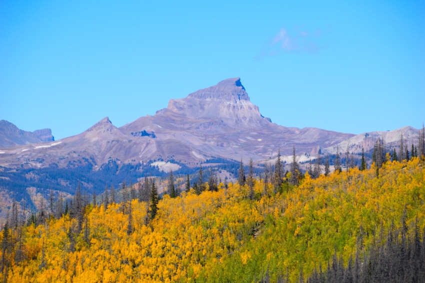
What mountain is that in the photo on this page?
This is Uncompahgre shot from the south.
I’ll have 6 days in late June and I would like to hit as many of the peaks as possible (assuming the peak or park will be open) excluding Elbert(completed) and any peaks in the Hardest category. What peaks or areas could you recommend to accomplish my goal to hit all the 14ers. Im coming in from eastern Kansas. Thanks!
Hey Chris, take a look at my map to find 14er locations which should help you create a plan: https://www.thevirtualsherpa.com/about-virtual-sherpa/colorado-hikes-map/
With 6 days, you can either try to knock out one a day or go for the grouped ones (Decalibron, Grays/Torreys/Castle Conundrum etc.) Keep in mind that late June will still have lingering snow for many peaks so be prepared with the necessary gear. If I were you, I would head to the Sangre’s. You can knock out Humboldt, Crestone Needle, Crestone Peak all in one camping spot. Beware it will be buggy in this area. With a shortish drive, you can head over to knock out Little Bear, Blanca and Ellingwood as well. That would be a jam packed 6 days, but certainly possible.
Hi Mick,
Long time fan and follower !
Would be great if you can add virtual 3D routes for your hikes, gives a much better perspective of the mountain. It’s free, simply upload your GPS file.
Here is the Bierstadt I’ve done yesterday: https://ayvri.com/scene/gdkzqzv2kz/ckbvf8v5q00013b69ktos8f7l
Cheers !
Thanks a ton Mick for all information!! Your youtube channel has been my goto site for planning for sometime now. Requesting to add ranks based on overall scenic views as well. Consider me interested party if you are planning to post something on route finding skills 🙂
Which 14ers are the “dog-worthy” ones? I’ve done Pikes, Grays, and Elbert w/ my dog already, but want to move beyond Class 1 and he always hikes with me (avg 15 mi day hikes) so interested to see what ones you think are more doable for dogs.
Hey Patti – any of the ones that I listed as class 1 or 2 are dog friendly for the most part. Once you get into 2 there can be some tougher conditions (loose rock/sharp rock/boulder hopping) but if your dog has worked through the class 1 ones, 2 should be no issue. For every hike on the website which talks about dogs so if there is anything above and beyond the normal worth mentioning, that is where I do it.
Excellent list! I’ve enjoyed reading your various trip reports.
Of course I have to debate the list. Quandary on the “More Difficult” list? That would be my biggest disagreement. I thought it was easier than most of the summits on the “moderate” list. And waaaay easier than Longs!
For “most scenic”, of the few 14ers I’ve summited, I would put Huron Peak & Sneffles (Blue Lake approach) at the top. Visually, Huron is just incredible.
Heading to the Sangre de Cristos in August, my first time there. I hope the mosquitos are gone from Willow Lake by then bc I ***hate*** mosquitos. Lots o’ 13ers in the Sangres which I prefer bc so few do them. I’ve never stood alone on a 14er summit and I’ve never shared a 13er summit. Thanks for all the reports!
Hey Mickey,
You’ve listed Mt Evans via Summit Lake in the easier category but the full description describes the Sawtooth ridge summit, which is definitely not easy. Cheers.
Love the list. So much of this depends on route. I would rank both Snowmass and Pikes Peak easier, as there are easier routes. But I’d say Kit Carson is harder than here, at least the way I did it. Cheers!
Hi Mickey! Love your channel and blog. I have a whole new respect for people filming while hiking, as I tried it today on Quandary.
Anyway speaking of Quandary, I have to agree with you on its difficulty. It makes me feel so much better that you didn’t categorize it as easy because my friend and I rode the struggle bus on it today! I still get to do more to compare, though, so fingers crossed the easier ones are easier than that.
Take care and thx for your awesome work!
Stacey
Thanks Stacey, appreciate the kind words – it can def be a challenge to balance it all especially when you are up higher in elevation.
My friend and I were overconfident and tried to climb Quandary in February 2017. It was subzero outside and yeah, that ended up with us getting whipped by snow tornadoes until our faces went numb. Wind blew snow over the trail and we lost it on the way down. Had to roll down the mountain for a few miles because the snow was too deep to walk in. Was absolutely brutal and a reminder that 14ers are no joke.
That said, love your content.
Im going to be going for my first 14er the last week of September with moderate hiking experience. So far I think narrowed it down to either Humboldt peak with the plan to start at the lower trail head and camp near the lakes. Then attempting to summit the next day. Other choice is mt. Shavanos also plan to make a two day trek, taking both slow and steady… What type of conditions should I expect and do these seem like solid choices? I like a little bit of a challenge but not gonna go too crazy. Just dont want a walk in the park hike, gotta earn it! Thank you for any advice and all your videos on YouTube!
https://www.patreon.com/thevirtualsherpa
Where does La Plata’s Ellingwood Ridge rank?
In the “hard” category for sure – a very very long and arduous day.